Environmental Factors in Commercial Real Estate Appraisal Haldimand County
Commercial values in Haldimand County seldom turn on rent rolls alone. The land remembers what happened on it, and the local environment sets boundaries you cannot negotiate away. Appraisers who work the corridor from Caledonia to Dunnville, across Hagersville to Nanticoke, carry mental maps of flood lines, former industrial footprints, capped fill sites, and microclimates along the Lake Erie shore. Those maps are not trivia. They shape risk, cost, and timing, which in turn shape value.
I have appraised warehousing near the Steel Company of Canada’s Lake Erie Works, farm-fronting contractor yards between Cayuga and York, small-bay industrial in Hagersville, and main-street commercial in Dunnville two blocks from a flood fringe. Here is the practical lens I use to weigh environmental factors in a commercial real estate appraisal in Haldimand County.
The local backdrop that drives environmental risk
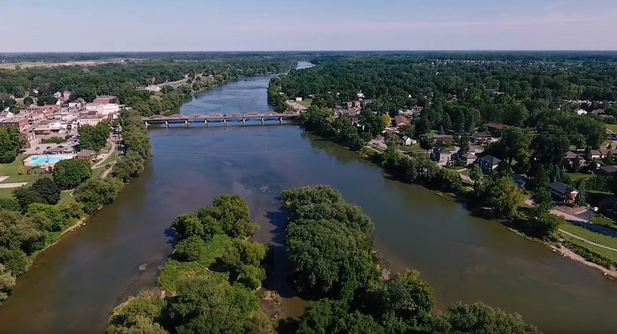
Two water systems define the county’s development pattern. The Grand River cuts a broad path north to south, pooling hazards in obvious lowlands and in a few not-so-obvious backlots that flood once a decade. Lake Erie pulls weather, influences shallow groundwater, and eats at bluffs faster in some reaches than aerial photos suggest. Layer on top of that a heavy industry legacy at Nanticoke, a long agricultural history with tile drainage and nutrient handling, and a modern phase of wind and solar projects strung across open land. Each leaves risk markers that matter in valuation.
-
Nanticoke industrial area: steelmaking and the decommissioned coal plant set expectations for soil and groundwater risk in the vicinity. Even fringe parcels, never built on, may carry stigma due to proximity and historical air deposition patterns.
-
Hagersville and Caledonia corridors: mixed commercial and light industrial on former farm fields. Fill placement to create development pads is common. Where did the fill come from, and when? That single question can swing a cap rate 25 to 75 basis points once lenders weigh in.
-
Dunnville and the Welland River: flood policy areas, conservation authority permits, and an occasional spring that turns basements into sumps. Insurance availability and deductibles are not academic. They show up in net operating income and exit pricing.
-
Lake Erie shoreline: stability issues, dynamic beach systems near Peacock Point and Selkirk, and the occasional septic system perched too close to a bluff. For commercial uses, that translates into foundation design, setback compliance, and a narrower buyer pool.
These realities are not reasons to avoid good assets. They are reasons to underwrite precisely.
Rules and regulators that shape feasibility
Environmental diligence in Ontario is not simply best practice. It is a compliance path that, if skipped, often surfaces during financing or refinance.
-
Conservation authorities: Haldimand sits under the Grand River Conservation Authority (GRCA) in the west and the Niagara Peninsula Conservation Authority (NPCA) to the east. Development in regulated areas needs permits. That can restrict building footprints, require floodproofing details, or reduce site coverage, which ripples into value for gas stations, car washes, self-storage, and other land-intensive uses.
-
Provincial policy and municipal overlays: the Provincial Policy Statement constrains development in significant wetlands, habitats, and hazard lands. Haldimand’s Official Plan and zoning by-law translate those constraints locally. I have seen minor variances take six months simply to validate an encroachment into a regulated slope, which is an eternity when a purchaser’s financing clock is ticking.
-
Environmental site assessments: Ontario Regulation 153/04 governs Records of Site Condition. You may not need an RSC for every deal, but lenders often demand a Phase I ESA for commercial loans and push for Phase II if any potential contaminating activity appears. The Ministry of the Environment, Conservation and Parks (MECP) soil and groundwater tables guide cleanup targets. If a site transitions to a more sensitive use, like industrial to mixed-use residential, the RSC becomes a gating item and a hard cost.
-
Excess soils and fill: O. Reg. 406/19 tightened the movement and tracking of fill. That matters for valuation whenever a site will be regraded. If you need to import 6,000 cubic metres to raise a pad above a flood line, testing and hauling rules can move an estimate from modest to material.
An appraiser does not substitute for environmental consultants or planners, but a competent commercial appraiser in Haldimand County should translate these constraints into time, money, and risk that flow through cash flows and rates.
Hydrogeology, soils, and what the ground will or will not bear
The county’s soils vary from silty clays near river deposits to sandy loams on former beach ridges. Under industrial sites near Nanticoke, fill is common. In agricultural fringes, you find tile drainage and perched water tables after heavy rain. A few practical observations affect value.
-
Septic versus municipal servicing: along the lakeshore and in rural hamlets with limited servicing, commercial users rely on private septic. For restaurants, daycare, breweries, or any high-water-use operation, septic capacity can cap the rent a tenant is willing to pay. I have discounted income streams where a 20-seat diner could not expand without an engineered system that might trigger conservation permits.
-
Bearing capacity and heave: silty clays near floodplains can complicate shallow foundations. If a pre-engineered building needs piles or a thickened slab, the cost-to-cure affects either the land residual or the buyer pool. That shows up in the cost approach and in developer conversations that set land comps.
-
Groundwater behaviour: shallow water tables near the Welland River and Grand backchannels push up foundation waterproofing and sump sizing. For appraisals, I test whether buyers will price this as a one-time capital or as a chronic risk. Frequent pump maintenance points to recurring operating costs, which weigh on net income.
Floodplains, erosion, and their translation into value
A flood line on a map is not an abstract. It is a set of limitations that influence leasable area, building placement, insurance, and financing. GRCA and NPCA mapping will show regulatory floodplains and erosion hazards. The more nuanced part is lender interpretation. Some lenders will close with a flood endorsement and higher deductibles, others will not touch a property where the building footprint actually lies within the regulated area.
For income assets, I watch two pricing effects. First, forced site design changes reduce productivity. A car wash pushed five metres north to clear a hazard line can lose stacking length and wash count. That is a revenue reduction, not a vague constraint. Second, residual stigma persists even after mitigation. I have seen fast-food sites that sit entirely outside the floodplain still trade 25 to 50 basis points wider on cap rate because access routes close in a 1-in-50-year event. Tenants price that interruption risk.
Shoreline erosion along Lake Erie adds a different wrinkle. The county and NPCA may require setbacks that make certain lots functionally obsolete for larger footprints. For small-scale commercial, that can force a pivot to seasonal uses, which produces lumpier income and again a wider cap rate. Buyers who plan to hold 15 years or more will ask for long-term erosion rate studies. Provide them early or expect retrades.
Agriculture at the property line
Haldimand County is still rural at its core. Many commercial properties sit beside active fields. That proximity brings dust, seasonal odours, and agricultural traffic. For automotive uses and equipment dealers, this is a feature. For daycares or health clinics, it may limit tenant demand. Nutrient management, crop spraying drift, and drainage tile networks can all come up in tenant interviews. When I appraise a mixed-use strip on a rural road, I ask leasing agents whether certain tenants passed solely due to adjacent farm activity. Enough no’s from daycare operators will convince me to trim my lease-up assumptions.
Tile drainage also places a subtle constraint on redevelopment. If a developer cuts off drain outlets or overloads existing tiles with impervious coverage, disputes follow. The county may require stormwater plans that increase soft costs and elongate timelines. That is still value, just later and with more friction.
Energy projects, utilities, and their footprints
Haldimand hosts the Grand Renewable Energy Park, with wind and solar installations spread across large tracts. For most commercial appraisals, the presence of turbines several kilometres away is neutral. Where it matters is in two edge cases. First, parcels that contain or abut solar arrays have access easements, setback constraints, and security fencing that reduce redevelopment options. Second, grid infrastructure upgrades tied to utility-scale projects sometimes unlock heavier service to nearby industrial land, which can support higher-value manufacturing or food processing tenants. I have seen quoting for 3-phase capacity sway a lease negotiation by enough margin to nudge value.
The shadow of the former coal plant at Nanticoke still influences underwriting. Buyers assume more scrutiny for any property within a short radius, even with clean ESAs. If the site once sat downwind of fly ash plumes, consultants may expand sampling grids. Appraisers should treat that as an underwriting item: longer due diligence and slightly higher transaction costs reduce the net price a rational buyer will pay.
Brownfields and the appraisal mechanics of contamination
If an environmental site assessment flags a potential contaminating activity, the valuation pivots from comparables to scenarios. Most lenders in the region will pause at a Recognized Environmental Condition, then request a Phase II. Results split into three practical buckets: clean, minor exceedances manageable with a risk assessment or soil management plan, and significant impacts needing excavation, vapour mitigation, or both.
Value drops fall into patterns I have observed across multiple assignments:
-
Cost-to-cure deduction: the simplest method, appropriate when remediation is defined and limited. If a petroleum hydrocarbon hotspot under a defunct pump island can be excavated for, say, 180,000 to 260,000 dollars including disposal and backfill, a buyer will often deduct that cost, add a contingency of 15 to 25 percent, and maybe a carry cost for the cleanup period.
-
Stigma after remediation: even with a Record of Site Condition, certain buyer pools demand a discount. The size of that discount varies. For a well-located automotive service building on Highway 6, I saw a 5 percent headwind that persisted for at least one resale after cleanup. For a retail site targeting daycare or medical, the pool shrank enough to widen cap rates by 50 to 100 basis points.
-
Time value and financing friction: lenders require environmental reports at commitment, often with peer reviews. Each iteration costs weeks. Developers with tight schedules will price that delay as a risk premium or ask for a price reduction to keep IRR targets.
An appraiser should not guess at remediation costs. Get third-party estimates or triangulate with recent local projects. Track tipping fees, haul distances, and whether soils can go to a reuse site under O. Reg. 406/19 or must head to landfill. That difference can move six figures on mid-size sites.
Insurance, tenants, and the way risk shows up in income
Environmental factors show in insurance quotes before they show in cap rates. In flood-prone pockets of Dunnville and Cayuga, deductibles can jump to 50,000 dollars and business interruption coverage may carve out flood events. Sophisticated tenants calculate expected uninsured losses over a lease term and push for rent concessions. Landlords either concede, raise base rents for low-risk tenants to average out, or accept a choppier rent roll. Any of those outcomes is an appraisal input.
For uses with material environmental exposure, like autobody or light manufacturing with solvents, landlords negotiate environmental clauses, require spill response plans, and sometimes collect larger security deposits. Stronger controls widen the tenant pool and support firmer cap rates. Lax controls do the opposite. During inspections, I open cabinets, look for secondary containment, and ask how used oil and filters are stored and hauled. These are operational signals that correlate with risk.
Sales comparison, income, and cost approaches under environmental uncertainty
The three standard approaches still apply to a commercial appraisal in Haldimand County. What changes is the way an appraiser weights them.
-
Sales comparison helps anchor land value and as-is conditions. But good comparables account for environmental encumbrances. A sale with pending remediation is not directly comparable to a clean site unless you can strip out the cost and stigma effects. In smaller markets like Haldimand, you may broaden the geography to Norfolk or Brant, then adjust for location and market depth.
-
The income approach captures ongoing constraints. Flood risk that pushes insurance up by 0.50 per square foot annually belongs in operating expenses. Tenant resistance that leaves bays empty for an extra month shows in stabilized vacancy. If a property needs vapour barriers to land a daycare tenant, that is a capital item with a schedule, not an abstract worry.
-
The cost approach becomes important for special-purpose assets and for brand-new construction in regulated areas. If a site requires a higher finish floor and engineered fill, the replacement cost new rises. External obsolescence may be appropriate if environmental stigma depresses market value below cost, a real possibility for niche buildings near perceived contamination.
When environmental factors loom large, I often run scenarios: clean as-is, remediated with known costs, and remediated plus stigma. Each scenario carries its own cap rate and timing. A clear narrative helps stakeholders make informed decisions.
Two local vignettes that changed pricing
A 12,000 square foot multi-tenant industrial building near Hagersville traded off-market after a Phase I flagged historical fill placement. The buyer’s lender required a Phase II. Results showed minor metals exceedances consistent with urban fill, manageable under a soil management plan during future site work. Before the report, pricing implied a 7.25 percent cap. After, the lender added conditions and the buyer asked for a price break equal to an extra 80,000 dollars for contingency and delay. The seller recovered part of that with a rent escalator on a renewal they were negotiating. Value moved, but not catastrophically, because the environmental narrative was credible and contained.
A highway commercial pad east of Caledonia sat within a GRCA regulated area with a 1-in-100-year flood fringe. Retailers loved the exposure but worried about access during peak events. A civil engineer proposed raising the pad 0.6 metres and designing a driveway that stayed passable in most storm scenarios. The fix added roughly 7 percent to site works. The developer absorbed the cost, then structured leases with co-tenancy and interruption clauses that reassured tenants. Exit pricing still widened 25 basis points compared with a similar store outside the fringe. The market paid for peace of mind, but not at a penalty that killed feasibility.
What lenders and insurers expect from a commercial appraiser Haldimand County
Local lenders do not want poetry. They want a tight summary of environmental constraints, how those show up in income, costs, marketability, and cap rate selection, and a view on whether further work is required. I include the following in narrative form: conservation authority status for the parcel, floodplain mapping references, a summary of ESA findings and consultant credentials, any pending municipal orders or permits, and insurance commentary based on broker quotes if available. When a property sits in a gray zone, I flag it and recommend conditions, not as a hedge, but as a map of practical next steps.
Insurers care about construction type, elevation, drainage, and proximity to known hazards. If a property has floodproofing measures or backup power for sump systems, say so. Specificity reduces perceived risk.
A focused due diligence list for owners and buyers
-
Order a Phase I ESA early and share it with your appraiser under reliance if possible. Surprises waste time.
-
Pull GRCA or NPCA mapping and verify whether any part of the building or drive aisles lies in regulated areas.
-
Confirm servicing. If on septic, get design capacity, age, and pump-out records; if municipal, request locates to check for old laterals and cross-connections.
-
Ask your broker for preliminary insurance terms based on the address and building details to avoid late-stage shocks.
-
Inventory any fill brought to the site since 2014 and gather reports, as O. Reg. 406/19 compliance may matter during site alterations.
Practical steps to protect or enhance value when issues surface
-
Quantify, then communicate. If a hotspot costs 200,000 to remediate with a 20 percent contingency, present that range, the contractor’s letter, and the schedule. Buyers pay for unknowns, not for defined work.
-
Align use with constraints. A contractor’s yard on a fringe parcel might be a higher-and-better-use than a dense retail site that fights setbacks, floodproofing, and parking ratios.
-
Stage improvements to reduce stigma. Complete vapour mitigation or floodproofing, document it, and market with third-party validation. Cap rates tighten when risk is pre-managed.
-
Negotiate environmental clauses that allocate operating responsibilities without scaring tenants. Balanced leases support rent and retention.
-
Build time into deals. Environmental review cycles with lenders and insurers rarely move in less than four weeks.
How seasoned appraisers integrate environmental factors without overreaching
The best commercial appraisal services Haldimand County can offer do not masquerade as environmental consulting. They translate technical findings into market behaviour. That means:
-
Reading ESAs for conclusions and limitations, not reinterpreting lab data.
-
Calling the conservation authority to confirm permitting realities when mapping looks ambiguous.
-
Reflecting insurance costs and exclusions explicitly in pro formas.
-
Interviewing brokers and buyers active in the county to understand cap rate spreads for properties near perceived risks.
-
Citing local sales, even if thin, and explaining adjustments plainly to account for stigma, delay, and cost-to-cure.
When those steps are followed, the final value opinion rings true to participants in the Haldimand market.
The keyword that never sells itself: context
Terms like commercial real estate appraisal Haldimand County or commercial appraisal services Haldimand County float around websites, but they only matter if paired with context. A commercial appraiser Haldimand County clients return to is the one who can look at a three-acre site near Cayuga, pull flood and erosion mapping, question a 1990s fill program, call the right person at GRCA, and tell a lender what that means for timing, cash flows, and exit value. A commercial property appraisal Haldimand County asset owner can rely on is the report that does not hide behind boilerplate when an ESA turns up a problem. If a deal needs a price adjustment or a re-sequenced development plan, say it straight and back it with numbers.
Data sources and ground truth
Desktop work only goes so far. Here is how I keep the analysis anchored. I visit https://www.instagram.com/realexappraisal/ the site in dry and wet periods when I can. I look for silt lines on block walls, rust on steel bollards at the base, staining around catch basins, and irregular settlement along paved edges that hint at poorly compacted fill. I ask tenants how many days a year they see pooling in the lot. I scan aerials across several years. I read municipal files for permit history and past orders. I talk to local contractors about typical tipping fees and haul distances to approved soil facilities. These small facts push an appraisal from generic to specific.
On the desktop side, I pull MECP well records to understand groundwater depths, conservation authority mapping for flood and erosion, and municipal GIS for zoning and servicing. For shoreline properties, I look at historical bluff retreat rates and whether the county has flagged any reaches for special attention. Then I test that knowledge against the market by calling brokers who have closed similar assets within the past year.
Where value lands when the environment is a headline risk
Investors in Haldimand County are pragmatic. They will pay fair prices for assets with defined environmental issues when returns compensate and timelines are credible. The heavy discounts appear when information is thin, remediation paths are vague, or regulatory sign-offs are uncertain. Clarity narrows spreads. If a site has no realistic path around a constraint, the highest and best use often changes. That is not failure. It is the market allocating land to the use that fits the ground.
What I tell clients is simple. Gather facts early. Share them with your appraiser and lender. Expect modest cap rate penalties for proximity to floodplains, brownfield stigma after cleanup, or shoreline constraints. Budget extra time for permits and reviews. And when you can engineer a solution, do it before you sell. The appraisal will reflect that work in a tighter rate, steadier income, and a broader buyer pool.
Commercial appraisal Haldimand County assignments reward discipline. The county’s mix of river, lake, farm, and factory makes for lively underwriting, but the principles do not change. Translate environment into economics, be specific, and keep your eye on what tenants, lenders, and insurers will actually do. That is where market value lives.